Wirt County Boundary Changes
Formation of Virginia
On 10 April 1606, King James I chartered two Virginia Companies, the Virginia Company of London and the Virginia Company of Plymouth. These two companies were to establish colonies along the coast of North America.
The first permanent settlement in Virginia was established at Jamestown in 1607.
On 2 June 1609, King James I granted a new charter to the Virginia Company of London, expanding jurisdiction westward and northwestward to the Pacific Ocean.
On 24 May 1624 the charter of the Virginia Company of London was revoked and Virginia became a royal colony. Ten Years later, in 1634, the original eight Shires (Counties) of Virginia were created. Although Virginia still claimed jurisdiction of all lands to the Pacific Ocean, these shires had defined western boundaries east of the mountains. One hundred years later, the westward expansion began.
Resources
Information and data for this page is derived in part from:
Atlas of Historical County Boundaries. A part of the The Newberry Library of Chicago, Illinois.
Scott, W.W., History of Orange County Virginia, Richmond Virginia: Everett Waddey Co., 1907
Formation of Orange County
On 1 January 1734 (O.S.), Orange County was established. Orange was divided from lands previously a part of Spotsylvania County, bounded on the north by the grant of Lord Fairfax and extended westward to the ‘utmost limits of Virginia’, which included modern Wirt County.
Orange County was formed about three years after Morgan Morgan settled near Bunker Hill.
The year 1734 witnessed the births of Daniel Boone and Paul Revere

Formation of Augusta County
On 1 November 1738, Augusta was formed from the western part of Orange County. By this time, the British only claimed territory to the Mississippi River.
The year 1738 witnessed the formation of Methodist Church.
Eight years later, in 1746, the Fairfax Stone was placed. This marker is located at the source of the North Branch of the Potomac River.
Later after surveys beginning in 1751, the Ohio Company sought to establish the fourteenth colony encompassing most of West Virginia and eastern Kentucky called Vandalia.

Formation of Botetourt County
In 1770, the southwest portion of Augusta was formed into Botetourt County. This division sliced through the southwest portion of modern Wirt County.
The year 1770 witnessed the birth of Ludwig van Beethoven.
Two years later, in 1772, Jesse Hughes discovered the Hughes River while exploring the Little Kanawha Valley.
Four years later, in 1774, the Battle of Point Pleasant was fought.
In 1776, settlers in the region attempted to create a fourteenth state, Westsylvania, with roughly the same borders as Vandalia.

Formation of Greenbrier County
By 1778, the southwest portion of Botetourt had been divided away to create Fincastle County containing modern day southwest West Virginia and all of Kentucky. Northern Augusta County had been divided to form West Augusta District. West Augusta District was quickly divided into Ohio, Monongalia, and Yohogania counties.
In 20 October 1778, Greenbrier County was formed from the northwestern portions of Botetourt County and a small part of Montgomery County.
In 1778 America was in its third year of the War for Independence and this was the year that France entered the war as an American ally.
The Greenbrier hotel was built in 1778.
The year 1778 witnessed the birth of Thomas Lincoln, Abraham Lincoln’s father.

Expansion of Monongalia County
In May of 1779, Monongalia County (formed in 1776) expanded to cover the northwestern portions of Augusta County.
In June of 1779 Spain declared war on Britain in support of the United States in the American Revolutionary War.

Creation of Harrison County
Virginia ceded all claims to the territory northwest of the Ohio river on 1 March 1784.
On 20 July 1784, Harrison County was formed from Monongalia County.
The year 1784 witnessed the birth of Nancy Hanks, Abraham Lincoln’s mother.
The year 1784 witnessed the ratification of the Treaty of Paris ending the American Revolutionary War.

Creation of Kanawha County
On 1 October 1789 Kanawha County was created from the northwestern parts of Greenbrier and Montgomery Counties.
In April of 1789 the United States House of Representatives and the United States Senate attain their first quorums; in a joint session they certify General George Washington as President-elect.
In July 1789 the French Revolution begins.
In 1790, the first census of the United States shows a population of 55,873 in modern West Virginia.
Seven years after the creation of Kanawha County, in 1796, William Beauchamp settled Beauchamp’s Mills at the site of present day Elizabeth.

Creation of Wood County
On 1 May 1799 Wood County was formed from the northwestern parts of Harrison County. This defined most of the southeastern boundary of modern Wirt County.
The year 1799 witnessed the death of George Washington.

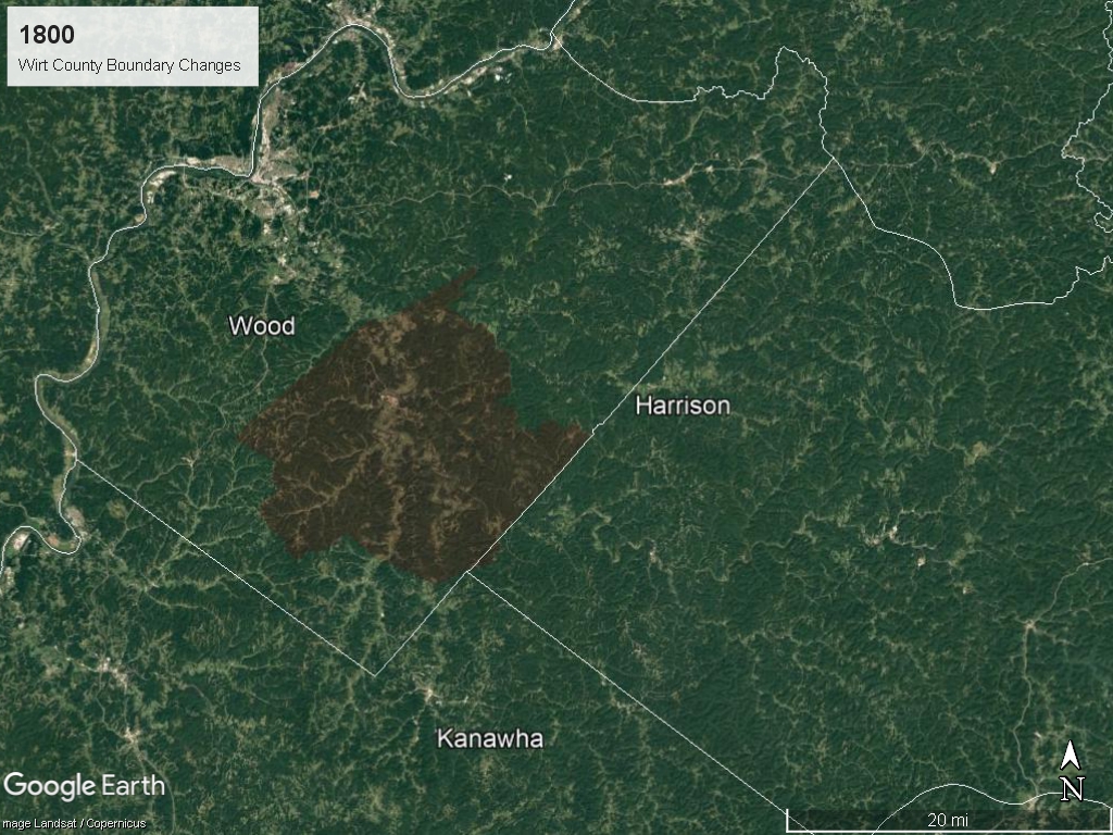
Expansion of Wood County
On 30 December 1800 Wood County expanded into Kanawha County. This rejoined the two parts of modern Wirt County.
In 1800, the second census of the United States shows a population of 78,592 in modern West Virginia.
On 24 April 1800 the U.S. Library of Congress is founded in Washington, D.C.
In the spring and summer of 1800, Gabriel Prosser planned Gabriel's Rebellion near Richmond, Virginia.
Formation of Mason County
On 1 May 1804 Mason County was created from the northwestern part of Kanawha County.
On 11 July 1804 Aaron Burr shot Alexander Hamilton during a duel.
In 1810, the third census of the United States shows a population of 105,469 in modern West Virginia.

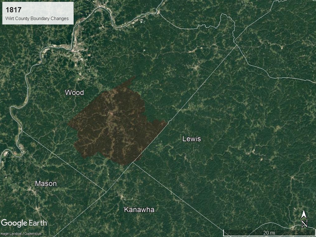
Formation of Lewis County
On 18 December 1816 Lewis County was created from Harrison County.
The year 1816 was the Year Without a Summer.

Exchange between Kanawha and Mason Counties
On 27 January 1817 Kanawha and Mason Counties exchanged land.
In 1820, the fourth census of the United States shows a population of 136,808 in modern West Virginia.
In 1830, the fifth census of the United States shows a population of 176,924 in modern West Virginia.
Formation of Jackson County
On 1 March 1831 Jackson County was created from Kanawha, Mason, and Wood Counties. This action again divided modern southwestern Wirt County.
In 1840, the sixth census of the United States shows a population of 224,537 in modern West Virginia.

Formation of Ritchie County
On 18 February 1843 Ritchie County was created from Harrison, Lewis, and Wood Counties. This action formed the northeastern boundary of modern Wirt County.

Formation of Gilmer County
On 3 February 1845 Gilmer County was created from Lewis and Kanawha Counties.

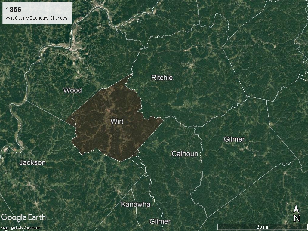
Formation of Wirt County
On 19 January 1848 Wirt County was created from Wood and Jackson Counties.
Wirt County was named in honor of William Wirt, who passed nearly 14 years prior.
On 24 January 1848 gold was found at Sutter's Mill in California; this is the beginning of the California Gold Rush.
In 1850, the seventh census of the United States shows a population of 302,313 in modern West Virginia.

Reduction of Wirt County
On 16 February 1853 Wirt returned the southern most portion of the county to Jackson County. This action formed most of the southwestern boundary of modern Wirt County.

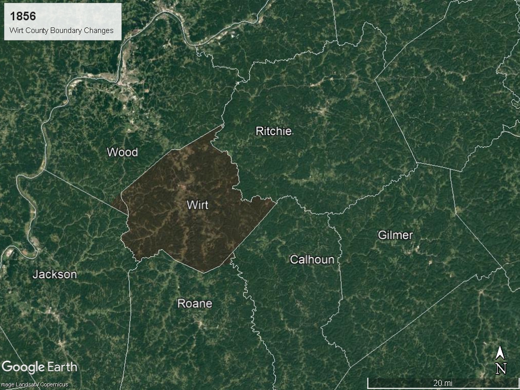
Formation of Calhoun County
On 5 March 1856 Calhoun County was formed from Gilmer County. This action actually divided Gilmer County into two parts. This division only lasted six days.
Formation of Roane County
On 11 March 1856 Roane County was formed from Gilmer, Jackson, and Kanawha Counties.
In 1860, the eighth census of the United States shows a population of 376,688 in modern West Virginia.
The year 1861 witnessed the Wheeling Convention, which gave rise to the Restored Government of Virginia.
Expansion of Wirt County
On April 20, 1863 Abraham Lincoln issued a proclamation to admit West Virginia into the Union 60 days later on June 20 1863.
On 7 October 1863 Wirt County gained the western corner of the county from Wood County.
In 1870, the ninth census of the United States shows a population of 442,014 in West Virginia.

Expansion of Wirt County
On 13 February 1872 Wirt County gained the a small portion of the southeastern corner of the county from Roane County.
In 1880, the tenth census of the United States shows a population of 618,457 in West Virginia.

The animation depicts modern Wirt County (shaded) as the county boundaries were formed from the founding of Virginia.
Each of the images are described above.